Current Projects
Tembak
Tembak is a village with a difference – they resisted overtures from a major timber company back in 1996, and have so far said no to palm oil companies, having witnessed the fallout experienced by other villages that have let the companies in. The village practices sustainable principles, with hydropower from a nearby river supplying the bulk of its electricity needs and the majority of villagers making a living by tapping rubber and farming. The villagers are welcoming of foreigners and receptive to the idea of eco-tourism, which they are working to implement in the near future with the help of experienced Indonesians and the Eco Warriors.
Tembak village is unique in other ways - it has offered 63 hectares of community forest to rehabilitate rescued orang utans alongside of Sintang Orangutan Centre run by the Kobus Foundation. The village also hopes to secure the 20,000-hectare forest they share with seven other nearby villages as a forest governed by traditional law (or the “hutan adat”). The forest now bears a concession status, which means it could be handed to companies by the government for business purposes. The 20,000-hectare forest, if secured as a “hutan adat”, will be the first such forest to be used for the release of rehabilitated orang utans.
Earthwatchers
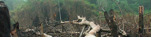
Over 75% of deforestation in Indonesia is illegal, compounded by difficulty in locating and identifying deforestation. Developed by Geodan, Earthwatchers is a ground breaking new software tool that enables participants from around the world to monitor the forests of Borneo and provide usable intelligence to help stop deforestation. Sign up to be an EarthWatcher!
The main objectives of this project are to:
- Involve Earthwatchers from around the world in forest conservation efforts via Satellite Earth Observation (crowdsourcing effort allocating small areas to millions of volunteers each), in turn increasing environmental and specific deforestation awareness;
- Make available and accessible different geographic layers of the specified area for the Earthwatchers to explore and understand the inter-relationship between biotic and abiotic factors in forest conservations (biodiversity layer, forest density, human accessibility and infrastructure, carbon deposits, etc).
- Develop crowdsourcing tools and techniques for human computation of radar earth observation deployed on a webGIS environment linked to social media to enable collaborative intelligence (joint decision by crowd wisdom) and improving the system by self-learning on results;
- Create awareness/learning materials about earth observation (especially radar) tailored to students aged 12-18
- Prove that useful results can be harnessed from radar earth observation analyzed using human computation (in a crowdsourcing effort).
Here's how it works:
- Each Earthwatcher is allocated a piece of land to monitor (hexagonal 1.6km2)
- New images are provided by radar satellite data providers allowing Earthwatchers to compare images and look for changes / disturbances.
- Earthwatchers report disturbances from within the program and collaborate with their neighbours, who hold the land around their hexagon, to explore whether or not the disturbance is related to illegal activity.
- Intelligence is sent directly back to the data center and information is shared with local authorities.
Register and become an Earthwatcher now!
To learn more about Earthwatchers, check out the Earthwatchers Wiki!
Learn, collaborate, and share through the Earthwatchers wiki! Housed in the DeforestACTION Collaboration Centre, the wiki hosts a glossary, explanations of deforested land and the types of satellite layers you can view through Earthwatchers. To sign-up, go to:
http://shout.tiged.org/dfahq/assistant/ and use the password: earthwatchers
You can also find more information on how to use the program by checking out the recordings of the Earthwatchers webinar: www.tigurl.org/earthwatch